
Alaska Winter Storm Warning: Why 2,500 Feet Decides Your Trip
24 to 36 inches above 2,500 feet and gusts to 65 mph in the eastern Alaska Range. What the warning means for passes, flights, and rebooking windows.
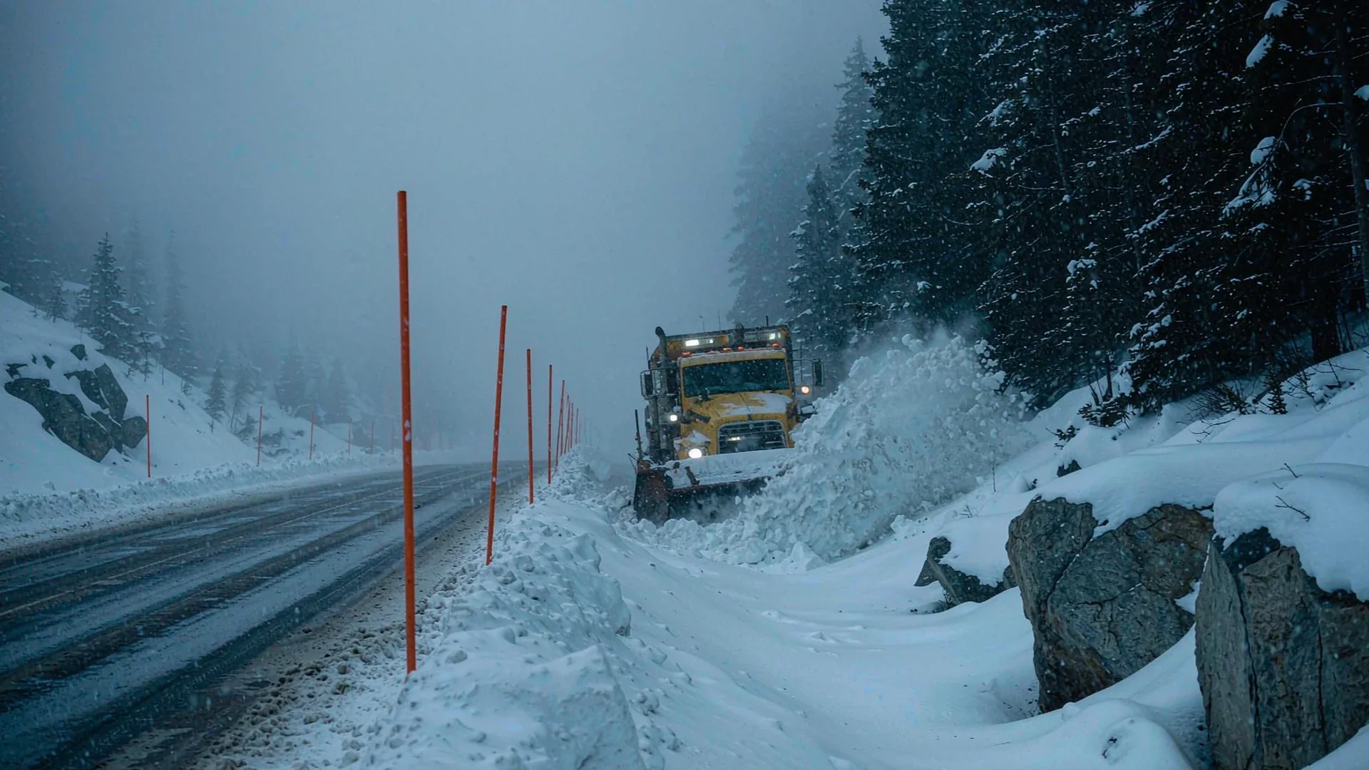
Alaska Winter Storm Warning: What 24 to 36 Inches Means for Anyone Trying to Travel
The warning went out at 10:08 a.m. local time on Monday, October 19, 2026, from the National Weather Service office in Fairbanks. By the time most travelers saw a headline, the Alaska winter storm it described had already started building over the eastern Alaska Range, and the first road reports were coming in from the Richardson Highway corridor. [source-1]
Here is the part the headlines flatten. The "30 inches" figure that traveled around the internet applies to one specific elevation band in one specific mountain range. [source-3] The town of Fairbanks is not under a winter storm warning at all. [source-1] It is under a lower-tier advisory with a forecast of 3 to 7 inches. [source-2] Those are two different products with two different meanings, and confusing them is how people either overreact and cancel a trip they could have taken, or underreact and drive a car into a mountain pass at the wrong hour.
This Alaska winter storm breakdown reads the actual warning text, converts it into numbers you can plan against, and separates the places where travel becomes genuinely impossible from the places where it becomes merely slow. [source-2]

Summary
- The National Weather Service in Fairbanks issued a Winter Storm Warning for the eastern Alaska Range at 10:08 a.m. AKDT on October 19, 2026, in force until 4:00 a.m. AKDT on Thursday, October 22. This was the 22nd winter storm warning the Fairbanks office issued in 2026.
- Forecast totals are 24 to 36 inches above 2,500 feet (roughly 610 to 914 mm above 762 m) and 12 to 24 inches below that line, with snowfall rates occasionally exceeding 1 inch per hour, or about 25 mm per hour.
- Winds gust to 40 mph (64 km/h) inside the warning area. A separate wind advisory covering the same corridor ran with gusts reported as high as 65 mph (105 km/h) on Monday.
- The warning was expanded eastward and inward on Sunday and Monday to cover the Yukon Flats, White Mountains, Upper Chena River Valley, Fortymile Country, Upper Tanana Valley, and Delta Junction, mostly at 5 to 10 inches.
- Fairbanks, North Pole, Fox, Ester, Chatanika, and Nenana sit under a Winter Weather Advisory rather than a warning, with 3 to 7 inches expected from 10 a.m. Tuesday to 4 p.m. Wednesday.
- The Alaska winter storm is arriving early enough in the season that some drivers have not yet switched to winter tires, which is a bigger risk factor than the snow depth itself.
What the National Weather Service actually issued
The warning carries a VTEC identifier of PAFG.WS.W 0022 and a severity classification of Severe, with certainty listed as Likely and urgency as Expected. Those three fields matter more than any single snowfall number, because they describe how confident the office is and how soon it expects the impact, not just how much snow might fall. [source-2]
The headline text is short and specific. Heavy snow expected. Total snow accumulations of 24 to 36 inches above 2,500 feet, with higher amounts above pass level, and 12 to 24 inches below 2,500 feet. [source-1] Winds could gust as high as 40 mph. Snowfall rates could exceed 1 inch an hour at times. Impacts: travel could be very difficult to impossible, and areas of blowing snow could significantly reduce visibility.
That word "impossible" is not marketing. It is the standard language the Weather Service uses when plowed capacity is expected to fall behind accumulation on a specific road segment, and it is a statement about the road rather than about the risk to a building. [source-6] Nothing in the warning says structures are threatened. Everything in it is about movement.
The Alaska winter storm also has a second half that most coverage skipped. Following strong southerly winds north of Trims Camp on Monday, heavy snow was expected to build Monday into Wednesday as winds shifted to out of the north. A wind shift of that kind reorganizes where the snow lands, which is why the forecast ranges are wide and why the advisory language leans on elevation rather than on towns. [source-2]
The snow totals, zone by zone
The warning is a set of polygons, not a single number. Reading it as a list of places is the only way to know whether your itinerary is inside one of them. [source-2]
| Zone | Forecast | Timing (AKDT) | What it means for travel |
|---|---|---|---|
| Eastern Alaska Range above 2,500 ft (762 m) | 24 to 36 in (610 to 914 mm) | Until 4 a.m. Thursday | Pass travel difficult to impossible; assume closure windows rather than delays |
| Eastern Alaska Range below 2,500 ft | 12 to 24 in (305 to 610 mm) | Until 4 a.m. Thursday | Slow but usually passable behind plows; chain and tire requirements likely |
| Yukon Flats, White Mountains, Upper Chena River Valley | 5 to 10 in (127 to 254 mm) | Tuesday 10 a.m. to Wednesday 4 p.m. | Secondary roads become the constraint, not the highway |
| Fortymile Country, Upper Tanana Valley, Delta Junction | 5 to 10, locally 10 to 15 in between Tanacross and Dot Lake | Monday 10 p.m. to Wednesday 4 p.m. | The Alaska Highway and Tok Cutoff become the exposure |
| Fairbanks, North Pole, Fox, Ester, Chatanika, Nenana | 3 to 7 in (76 to 178 mm), advisory not warning | Tuesday 10 a.m. to Wednesday 4 p.m. | City driving slows; flights mostly unaffected |
Two details in that table deserve their own paragraph. The first is that the warning boundary between light and heavy snow around Eielson AFB, Salcha, Harding Lake, and Two Rivers is expected to be very sharp, which means totals depend on precisely where the line sets up rather than on a gradual gradient. The second is that snow between Northway and the Canadian border was forecast at only 1 to 3 inches with rain possibly mixing, so a route that looks uniformly bad on a regional map may have a wet, mild segment at one end. [source-2]
Why 762 m is the line that matters
Every number in the warning is conditional on elevation, and 2,500 feet is roughly 762 m. [source-1] Above that line the forecast doubles. Below it, the forecast halves. For a driver this is not a meteorological curiosity, it is the difference between a two-hour delay and an unplanned night in the car.
The Richardson Highway between Mile Post 202 and 259 passes through Trims Camp, Donnelly Dome, and Black Rapids. [source-6] That is a 57-mile segment, roughly 92 km, that climbs through the band where the forecast is at its heaviest. Isabel Pass sits inside the same corridor. A traveler who checks the forecast at Fairbanks and then drives this segment has checked the wrong place, because the conditions that close the pass are generated 762 m above the city. [source-6]
The correct reference points for this Alaska winter storm are the pass-level forecasts and the road-condition feed at 511.alaska.gov, not the city forecast. [source-6] The Weather Service wording points travelers at exactly that resource, and the road feed updates on a different cadence than the weather warnings.
Ground clearance: the number that strands cars
The most useful mechanical figure published alongside this storm is vehicle ground clearance, because high-centering is how cars actually get stuck in deep snow rather than losing traction in the ordinary sense. [source-6]
| Vehicle class | Ground clearance | Forecast snow at Delta Junction and Tok |
|---|---|---|
| Subaru Outback | 8.7 in (221 mm) | 5 to 10, locally to 15 in |
| Subaru Forester Wilderness | 9.3 in (236 mm) | Exceeded in the heavier bands |
The arithmetic is uncomfortable. Snow totals forecast around Delta Junction and Tok can exceed the ground clearance of a crossover marketed for exactly this kind of driving. When snow builds under the body, the vehicle rests on it and the tires lose contact with the road surface, at which point more throttle makes the situation worse rather than better. [source-6]
The recovery sequence, in order: stop spinning the wheels, clear the tailpipe, dig under the floor of the car rather than only around the tires, straighten the wheels, then add traction material under the driven wheels. A blocked exhaust can push carbon monoxide into the cabin while the engine idles, which converts a stuck car into a medical emergency. Stay with the vehicle if it will not move, because a stuck car is far easier to locate than a driver on foot. [source-6]
Fairbanks itself is under an advisory, not a warning
This is where most trip decisions go wrong. Fairbanks, North Pole, Fox, Ester, Chatanika, and Nenana are not inside the winter storm warning. [source-1] They are inside a Winter Weather Advisory from 10 a.m. Tuesday to 4 p.m. Wednesday, with 3 to 7 inches forecast and genuine uncertainty about whether the heavier band shifts just east or just west of town.
An advisory is a lower-tier product than a warning, but it still means slick and slow roads. [source-2] What it does not mean is that the town shuts down. Interior Alaska operates through this kind of snow routinely, and a 3-to-7-inch forecast is a plow schedule rather than an event. [source-2]
For a traveler based in Fairbanks, the practical consequence of this Alaska winter storm is that the risk is concentrated in exactly two places: the mountain passes if you drive toward them, and the flight if your aircraft is arriving from somewhere that got hit harder. [source-6] The town itself is the least exposed part of the story.

What happens to flights at Fairbanks
The warning does not address aviation directly, and that distinction is worth keeping. A winter storm warning describes ground accumulation and visibility at the surface. [source-1] It is not a flight forecast, and it is not a substitute for an aviation weather briefing.
What the storm plausibly affects is the inbound leg. Aircraft arriving at Fairbanks International from the south cross the Alaska Range, and the same moisture feed that produces 24 to 36 inches in the passes produces the cloud and visibility conditions that force alternate routings or holding. [source-1] The report from the Air Sports Net summary makes this explicit as an inference rather than an official flight forecast: low clouds, reduced visibility in falling or blowing snow, and difficult mountain-pass conditions are the expected pattern near the range and eastern Interior routes. [source-6]
The actionable version is straightforward. If your itinerary depends on a same-day connection through a southern hub into Fairbanks, build a buffer day rather than a buffer hour. If your flight is disrupted and the cause is coded as weather, the compensation· question is very different from a mechanical delay, and the eligibility determination is what matters. Services such as AirHelp exist to run that determination across jurisdictions before you spend time on a claim that does not exist.
The highway picture
Four highways carry the exposure in this Alaska winter storm, and they do not behave the same way. [source-6]
| Highway | Segment affected | Forecast exposure | Practical note |
|---|---|---|---|
| Richardson | Mile Post 202 to 259 (Trims Camp, Donnelly Dome, Black Rapids) | 24 to 36 in above 762 m | The pass segment; check the road feed before committing |
| Richardson | Mile Post 295 to 346 | 5 to 10 in | Closer to Fairbanks, lower totals, still slick |
| Dalton | First 38 miles (61 km) | 5 to 10 in | Industrial traffic; give plows and trucks room |
| Steese and Elliott | Above Mile Post 124 and through the White Mountains | 5 to 10, higher-terrain gusts to 35 mph | Visibility becomes the limit before depth does |
| Alaska Highway, Tok Cutoff, Taylor Highway | Delta Junction through Tok, Chicken to Eagle | 6 to 12, locally to 15 in | Long stretches without services; fuel before you commit |
| Chena Hot Springs Road | Mile Post 12 to 34 | 5 to 10 in | Resort traffic; a wrong-hour decision is the risk |
The pattern across the table is that depth is not the controlling variable everywhere. On the Steese and Elliott, gusts to 35 mph (56 km/h) on higher terrain can cut visibility below half a mile, which is about 0.8 km, long before the road is buried. Blowing snow closes roads in ways that accumulation does not. [source-6]
How this compares to a normal October
Context changes a decision more than a forecast does. Alaska recorded 4 winter storm warnings in October 2026, against an average of 3 in an October across 2008 to 2025. [source-1] That is a modest difference, not an unprecedented one.
The more useful comparison is the seasonal count. This was the 22nd winter storm warning issued by the Fairbanks office in 2026, which puts the year on a normal-or-slightly-above trajectory rather than an extreme one. [source-1] An October storm in Interior Alaska is a scheduled event, not an anomaly, and the infrastructure is built for it. [source-2]
| Measure | This event | Baseline |
|---|---|---|
| October 2026 winter storm warnings, Alaska | 4 | 3 average, October 2008 to 2025 |
| Fairbanks office warnings, year to date | 22 | No comparable prior-year count published in the warning record |
| Fairbanks forecast | 3 to 7 in advisory | Town routinely handles this band |
| Eastern Alaska Range forecast | 24 to 36 in above 762 m | Pass-level closures occur most winters |
What is genuinely early is the timing relative to driver preparation. The storm lands in the third week of October, when some vehicles still carry all-season tires. Tire compound loses grip well before tread depth becomes the issue in cold snow, and that is the mechanism behind a large share of early-season incidents. A rental car picked up in Fairbanks in October should be checked for winter-rated tires rather than assumed to have them. Booking a vehicle with an explicit winter specification, through a service such as Economybookings, is cheaper than discovering the gap at the pass. [source-6]
The aurora question
Late October is inside the aurora season in Interior Alaska, which runs roughly from late August to mid-April, and this is the reason many travelers are in Fairbanks at all during a snowstorm. [source-2]
The honest answer is that this Alaska winter storm is bad for aurora viewing and neutral for aurora trips. Cloud cover is the controlling variable for seeing the lights, and a heavy snow event means thick cloud. What the storm does not do is cancel a trip whose purpose is to be in the right place on a later clear night. Aurora forecasting operates on a shorter horizon than a storm warning, and a 3-day trip has a reasonable chance of containing one clear night even inside a stormy week. [source-2]
The practical framing: treat the storm days as the days you do not chase the lights, and keep a flexible day in the middle. The Chena Hot Springs Road corridor stays open at advisory levels, and the springs themselves operate in this weather. [source-2]
What to do if you are driving into it
The Weather Service's own instruction is short: if you must travel, keep an extra flashlight, food, water, and warm clothing in your vehicle, and check 511.alaska.gov or call 511 for the latest road conditions. [source-6] That is the entire official recommendation, and it is worth taking literally.
Beyond it, four decisions do most of the work.
Decide on hours rather than on days. The heaviest period was forecast from Monday night through Tuesday night in the Alaska Range, and Tuesday into Wednesday for many Interior communities. A departure shifted by eight hours can be the difference between the pass and a pullout. [source-6]
Decide on a turnaround point before you leave. Pick the mile post or the town where you turn around if conditions are worse than forecast, and name it out loud. Drivers who decide mid-pass tend to keep going. [source-6]
Decide on connectivity before the drive. Interior Alaska has long stretches without reliable coverage, and a prepaid eSIM installed before departure keeps the road feed and the warnings reachable at the moments they change. [source-2] It costs less than a night in a motel you did not plan for.
Decide on insurance· with the wording in front of you. Snow closure is treated differently from a mechanical breakdown and differently again from a cancellation you initiate. A policy that covers weather-delayed arrival and a stranded-night expense, such as EKTA, addresses the specific failure this storm produces rather than the general category of travel trouble.
Outlook: Tuesday through Thursday
The warning expires at 4 a.m. AKDT on Thursday, October 22, and the practical calendar inside that window is short. Tuesday and Tuesday night carry the heaviest period in the range. Wednesday is when many Interior communities see their accumulation. Thursday morning is the first realistic window for pass travel, and even then it depends on plow progress rather than on the forecast ending. [source-6]
Beyond the storm, the Climate Prediction Center's 6 to 10 day outlook favors above-normal temperatures and precipitation across mainland Alaska from October 24 to 28, with forecasters pointing to an active surface low track across the Bering Sea and Gulf of Alaska. [source-5] In plain terms, the pattern stays wet. A traveler with flexibility should not expect a dry, cold, stable week to follow this system; the more likely sequence is more snow at pass level and warmer, messier conditions in town. [source-6]
That forecast changes one piece of advice. If your plan involved waiting out the storm in Fairbanks and then driving the Richardson Highway on Friday or Saturday, the outlook argues for checking the road feed again on Thursday night rather than assuming the pass is finished with the season. [source-5]
FAQ
Is Fairbanks under a winter storm warning? [source-1]
No. Fairbanks, North Pole, Fox, Ester, Chatanika, and Nenana are under a Winter Weather Advisory from 10 a.m. Tuesday to 4 p.m. Wednesday with 3 to 7 inches forecast. The Winter Storm Warning covers the eastern Alaska Range and, after expansion, several eastern Interior zones. [source-5]
How much snow is actually coming?
It depends entirely on elevation. Above 2,500 feet, which is about 762 m, the eastern Alaska Range forecast is 24 to 36 inches, or roughly 610 to 914 mm. [source-1] Below that line it is 12 to 24 inches. Fairbanks town is forecast at 3 to 7 inches.
Is the Richardson Highway closed?
The warning does not close a road; it forecasts conditions that make travel difficult to impossible. Road status is a separate feed at 511.alaska.gov. [source-6] On the Mile Post 202 to 259 segment the forecast is heavy enough that closure windows should be assumed rather than ruled out.
Will my flight be cancelled?
A winter storm warning is not a flight forecast. [source-1] The plausible mechanism is inbound aircraft crossing the Alaska Range in low cloud and reduced visibility. Build a buffer day on connections rather than a buffer hour.
Can I still see the northern lights?
Not during the heavy snow, because cloud is the limiting factor. Late October is inside aurora season, and a multi-day trip has a reasonable chance of one clear night even in a stormy week. Keep a flexible day rather than cancelling on the forecast alone. [source-1]
Is this an unusually bad October?
No. Alaska recorded 4 winter storm warnings in October 2026 against an average of 3 for October across 2008 to 2025, and this was the 22nd warning the Fairbanks office issued in 2026. [source-1] The early-season tire situation is the bigger variable.
Snow totals in this article are the National Weather Service forecast ranges as issued, converted to metric for international readers. Ground clearance figures are manufacturer specifications. Where a figure is an inference rather than a published measurement, it is described as such in the text. [source-1]
Sources
- [source-1] National Weather Service Fairbanks: Winter Storm Warning, Eastern Alaska Range
- [source-2] Air Sports Net: Interior Alaska snow threat expands beyond the Alaska Range
- [source-3] Economic Times: Alaska winter storm warning, up to 30 inches of snow and 65 mph winds
- [source-4] Autoblog via AOL: Winter Storm Warning, up to 36 inches of snow and 40 mph gusts
- [source-5] NWS Fairbanks area forecasts and discussions
- [source-6] Alaska road conditions 511: Alaska road conditions: 511.alaska.gov