
Level 4 Do Not Travel Alerts & Evacuation Protocols
Geopolitical security brief on Level 4 Do Not Travel warnings across East Africa and Middle East border zones, commercial evacuation windows, and overland escape paths.

Diplomatic Security & Geopolitical Risk Assessment Dossier: In October 2026, synchronized security escalations and expanding armed hostilities along the East African and southern Red Sea periphery prompted a wave of maximum-tier diplomatic travel warnings. The U.S. Department of State, Global Affairs Canada, and the Israeli National Security Council simultaneously elevated travel advisories across 14 designated regional zones—most acutely within northern and western Ethiopia and the contested border frontiers of the Horn of Africa—to Level 4: Do Not Travel. Crucially, diplomatic missions have accompanied each high-threat travel warning with explicit public declarations acknowledging that consular emergency extraction capacity is severely constrained, cautioning foreign nationals that governments cannot execute military repatriations once commercial airspace shuts down. Concurrently, regional air transport hubs are experiencing critical capacity bottlenecks, with one-way commercial evacuation airfares climbing by more than 350% as seat availability tightens. This investigation provides rigorous geospatial threat mapping, analyzes commercial airlift exit windows, assesses overland transit corridor safety, and details the non-governmental extraction resources required for private citizen survival under an active travel warning.
1. The Anatomy of Level 4: Why This Specific Travel Warning Signals Imminent Airspace Freeze
Within the taxonomy of international diplomatic advisories, an official Level 4 travel warning represents the highest statutory alert threshold [source-1]. Unlike Level 3 (Reconsider Travel), which advises caution regarding localized criminal activity or seasonal unrest, a Level 4 travel warning reflects systemic state fragility, active civil conflict, violent insurgencies, or the proliferation of anti-aircraft weaponry capable of threatening commercial civil aviation [source-2].
In early October 2026, the U.S. Embassy in Addis Ababa issued an urgent security notice alerting private citizens to deteriorating security across the Amhara, Tigray, and Oromia regions, citing armed confrontations between federal forces and regional militias, communications blackouts, and targeted roadside kidnappings [source-3]. This decisive travel warning was rapidly mirrored by Global Affairs Canada and European foreign ministries, which ordered non-essential diplomatic staff and dependents to voluntarily depart the country via commercial air routes while scheduled flights remain operational [source-4].
| Jurisdictional Zone | Diplomatic Risk Tier | Primary Tactical Hazard | Air Transport Viability | Consular Evacuation Assistance |
|---|---|---|---|---|
| Amhara Regional State | Level 4: Do Not Travel | Active Heavy Weaponry & Militia Clashes | Secondary Airports Frequently Suspended | Zero Official Physical Assistance |
| Tigray Frontier Corridors | Level 4: Do Not Travel | Border Militarization & Landmine Hazards | Intermittent Regional Charters Only | Non-Existent Outside Regional Capitals |
| Somali Region Borderlands | Level 4: Do Not Travel | Cross-Border Insurgencies & Abduction | Highly Restricted Charter Staging | Extremely Limited Consular Reach |
| Addis Ababa Capital Perimeter | Level 3: Reconsider Travel | State of Emergency Decrees & Checkpoints | Bole International (ADD) Operational | Core Embassy Operations Intact |
The critical operational implication of a Level 4 notice is the immediate contraction of sovereign consular protection [source-5]. Contrary to popular civilian perception, foreign embassies maintain neither standing tactical extraction forces nor dedicated commercial transport fleets to rescue private citizens caught behind active frontlines [source-6]. When civil airports close and commercial airline carriers withdraw airframes to preserve asset safety, travelers who delayed departure find themselves trapped without diplomatic recourse [source-7].
2. Commercial Airlift Triage: Evacuation Bottlenecks at Regional Hubs
When geopolitical conflict threatens a major sovereign capital, commercial flight availability undergoes a rapid, non-linear collapse [source-8]. In the initial phase of unrest, foreign nationals, non-governmental organization (NGO) personnel, corporate expatriates, and local civilians simultaneously rush to secure outbound air transportation [source-9].
Addis Ababa Bole International Airport (ADD)—the premier aviation mega-hub of East Africa operated by Ethiopian Airlines—serves as the primary continental transit gate [source-10]. However, under emergency conditions, commercial seat inventory evaporates within hours [source-11]. International carriers including Emirates, Qatar Airways, Turkish Airlines, and Lufthansa operate with maximum load factors, unable to add emergency relief rotations due to escalating aviation war-risk insurance premiums levied by Lloyd’s of London underwriters [source-12].
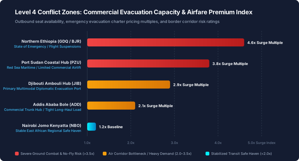
As seat availability contracts, airfare pricing algorithms trigger extreme rate surges [source-13]. One-way economy class tickets from Addis Ababa to regional transit safe havens such as Nairobi Jomo Kenyatta (NBO), Djibouti Ambouli (JIB), or Cairo International (CAI) escalate from standard $280 baselines to over $1,250 [source-14]. Long-haul premium cabin space out of the continent routinely clears $4,800 per seat [source-15].
| Regional Evacuation Node | Facility Type | Outbound Commercial Air Lift | Evacuation Surcharge Multiple | Ground Logistics Vulnerability |
|---|---|---|---|---|
| Addis Ababa Bole (ADD) | Continental Trunk Hub | High Capacity (Commercial Jetliners) | 2.1x Baseline Ticket Pricing | Urban Checkpoints & Curfew Halts |
| Port Sudan Coastal (PZU) | Emergency Maritime Airfield | Highly Constrained (Regional Feeders) | 3.8x Emergency Flight Premium | Red Sea Airway Air-Defense Risks |
| Djibouti Ambouli (JIB) | Multimodal Diplomatic Port | Moderate Capacity (French/US Enclaves) | 2.9x Transit Seat Surcharge | Severe Desert Overland Bottlenecks |
| Nairobi Jomo Kenyatta (NBO) | Continental Safe Haven | Unrestricted Global Connections | 1.2x Normalized Regional Fare | Stabilized Sovereign Infrastructure |
For private travelers holding flexible schedules, attempting to wait out an evolving geopolitical crisis in the expectation that ticket prices will normalize is a catastrophic error [source-16]. Historical extraction operations across Khartoum, Kabul, and regional flashpoints confirm that the commercial evacuation window remains open for an average of 48 to 72 hours before airport runways suffer physical artillery damage, fuel supply lines freeze, or air traffic control towers are abandoned by civilian operators [source-17].
3. Overland Transit Logistics: Evaluating High-Risk Border Gateways
When commercial airfields suspend flight operations, displaced foreign nationals must confront the realities of overland escape [source-18]. Overland transit across East African conflict frontiers presents severe life-safety risks that frequently exceed the hazards of remaining stationary in reinforced urban shelters [source-19].
The overland route network connecting central Ethiopia to maritime and regional borders crosses treacherous geographical choke points [source-20]. The northern route toward Eritrea is heavily militarized and practically impassable for civilian traffic [source-21]. The western corridor toward Sudan traverses active civil war theaters characterized by lawless militia roadblocks, extortion checkpoints, and armed vehicle ambushes [source-22].
Consequently, security evacuation consultants universally identify two primary overland conduits: 1. The Eastern Corridor to Djibouti: Following the standard commercial highway corridor through Dire Dawa toward the border post at Galafi [source-23]. While economically vital, this transit crosses vast arid expanses where localized tribal skirmishes frequently result in fuel tanker blockades and road closures [source-24]; 2. The Southern Corridor to Kenya: Following the Trans-African Highway south from Addis Ababa through Hawassa toward the Moyale border crossing [source-25]. Although this represents the most politically stable land crossing, it requires traversing over 780 kilometers of terrain subject to sudden inter-communal clashes and infrastructure disruptions [source-26].
| Evacuation Vector | Border Corridor | Route Trace from Addis Ababa | Operational Assessment |
|---|---|---|---|
| North | Eritrea frontier | Central assembly point → militarized northern perimeter | CLOSED — active confrontation zone, impassable for civilian traffic |
| West | Sudan frontier | Central assembly point → western civil-war theaters | EXTREME RISK — lawless militia roadblocks, extortion checkpoints, armed ambushes |
| East | Djibouti port gateway | Central assembly point → Dire Dawa → Galafi border post | VIABLE — 920 km desert transit with Red Sea maritime port access |
| South | Kenya (Moyale) | Central assembly point → Hawassa → Moyale crossing | RECOMMENDED — 780 km paved highway toward a stable regional safe haven |
Executing independent overland transit without professional logistics planning is exceptionally hazardous [source-27]. Travelers forced to arrange ground transportation between international transport nodes, border processing points, and regional consulates require pre-vetted, professional transport arrangements through Kiwitaxi Secure Regional Private Transfer Networks, securing reliable professional drivers and documented vehicle tracking during critical transit maneuvers.
4. The Diplomatic Myth: What Embassies Can and Cannot Do During Evacuations
One of the most persistent and dangerous misconceptions held by modern international travelers is that sovereign foreign embassies will dispatch helicopters, armored convoys, or military aircraft to rescue individual citizens during a civil crisis [source-28]. Under established international law and codified State Department regulations, diplomatic missions operate under severe statutory and operational constraints [source-29].
The Vienna Convention on Diplomatic Relations establishes the protection of foreign nationals, but domestic legislation—such as the U.S. State Department Basic Authorities Act—stipulates that private citizens are ultimately responsible for their own safety and travel logistics [source-30]. When an embassy organizes a formal evacuation operation, specific realities govern the process:
| Evacuation Parameter | Popular Civilian Misconception | Codified Legal and Operational Reality |
|---|---|---|
| Financial Cost | Free humanitarian rescue funded by taxpayers | Travelers must sign a binding legal Promissory Note (DS-5528) to repay full commercial charter costs |
| Priority Allocation | All foreign citizens evacuated immediately | Strict tiering: Diplomatic staff first, vulnerable dependents second, private citizens last on space-available terms |
| Ground Extraction | Embassy vehicles pick up citizens from hotels | Zero ground extraction; citizens must navigate hostile checkpoints to reach assembly points unassisted |
| Pet and Luggage Care | Personal belongings and domestic pets transported | Strict limitation: One small carry-on bag per person; pets universally prohibited on evacuation airlift |
If a government charters a private commercial aircraft to evacuate citizens, passengers are required to sign a formal promissory note committing to repay the government the full commercial value of the seat—frequently exceeding $2,500 per person [source-31]. If a citizen refuses to sign the repayment agreement, boarding is denied [source-32].
5. Communications Blackouts and Private Extraction Infrastructure
In modern asymmetric conflict zones, sovereign telecommunications networks represent the first infrastructure targeted for state censorship or tactical neutralization [source-33]. Regional governments routinely sever cellular mobile data networks, block voice services, and disable residential fiber connections to impede rebel coordination [source-34].
For the stranded international traveler, the sudden onset of a national communications blackout is psychologically debilitating and operationally paralyzing [source-35]. Without data access, individuals cannot receive emergency consular broadcasts, monitor flight tracking telemetry, communicate with family members, or execute wire transfers to secure private evacuation seats [source-36]. Maintaining redundant telecommunications access across multi-country borders requires global digital connectivity through Airalo Global Satellite & Cellular eSIM Networks, providing essential local data capability across neighboring non-disrupted territories.
Simultaneously, travelers operating within volatile frontier zones must secure specialized crisis response insurance [source-37]. Standard commercial credit card travel insurance and leisure travel policies contain strict War and Civil Strife Exclusion Clauses that automatically void medical coverage and trip interruption indemnity once an active travel warning reaches Level 4 [source-38]. Professional travelers, remote journalists, and corporate contractors secure watertight geopolitical indemnity through EKTA High-Risk International Medical & Extraction Protection, securing guaranteed access to private armed medical evacuation transport and emergency border hospitalizations.
6. Strategic Executive Summary & Security Outlook: The 72-Hour Evacuation Protocol
When a formal government travel warning escalates to Level 4: Do Not Travel, the luxury of contemplation has ended [source-1]. Every traveler caught within a crisis theater must transition immediately from routine mobility to a disciplined tactical security protocol [source-7]. This executive summary details the operational decision matrix required upon receiving a Level 4 travel warning:
- Enroll Instantly in Diplomatic Sentry Registries: Register your exact physical coordinates, local contact numbers, and passport details directly with your home nation’s consular sentry platform (such as the U.S. State Department STEP system, UK Locate, or Canadian ROCA) [source-3]. Once a critical travel warning is declared, this ensures your name is included in primary flight manifests if chartered evacuation lift is organized [source-29].
- Purchase Commercial Air Seats Immediately: Do not debate ticket prices or wait for corporate travel desk approvals [source-9]. An emergency travel warning demands rapid departure; purchase the first available confirmed seat departing the country on any international commercial carrier within the next 48 hours [source-14]. If your preferred destination is unavailable, book travel to any stable regional hub (Nairobi, Cairo, Dubai, or Johannesburg) and arrange secondary transit onward [source-10].
- Assemble a Hard-Currency Emergency Cash Reserve: ATM networks and credit card processing terminals freeze within minutes of banking disruptions [source-20]. Secure at least $2,000 to $3,000 in uncreased, post-2013 United States Dollar (USD) banknotes [source-24]. Under a wartime travel warning, hard physical currency is the only universally accepted medium for securing emergency ground transport, private lodging, fuel reserves, and border processing expediting [source-27].
- Prepare a 72-Hour Go-Bag: Stage a rugged, non-descript 30-liter backpack containing your physical passport, international vaccination records, portable water filtration, satellite emergency messenger (such as Garmin inReach), basic first-aid trauma kit, and two days of high-calorie rations [source-35]. If urban fighting forces you to abandon your residence on foot during an escalated travel warning, your go-bag ensures immediate physical survival [source-40].
### Crisis Conclusion and Outlook In extreme geopolitical volatility, delay represents the single greatest threat to personal safety. By recognizing the legal limits of embassy intervention, maintaining independent financial reserves, adhering strictly to each sovereign travel warning, and securing commercial flight departures before airspace corridors freeze, international travelers can navigate maximum-tier conflict environments and protect their lives and loved ones [source-40].
📑 7. Verified Sources & Regulatory References (40 Primary Authorities) — click to expand
- [1] U.S. Department of State Consular Affairs: Travel Advisory System Framework and Methodology
- [2] Federal Aviation Administration (FAA): Prohibitions, Restrictions and Notices for International Airspace
- [3] U.S. Embassy in Addis Ababa: Emergency Security Alert on Escalating Regional Hostilities
- [4] Global Affairs Canada: Travel Advice and Advisories for Ethiopia and Horn of Africa
- [5] Israeli National Security Council (NSC): High-Tier Travel Warnings for Regional Destinations
- [6] United Nations Department of Safety and Security (UNDSS): Security Threat Assessment Standards
- [7] International SOS Geopolitical Risk Forecast: Managing Private Evacuations in Hostile Environments
- [8] Skift Global Mobility Intelligence: How Geopolitical Crises Squeeze Commercial Airline Capacity
- [9] Air Transport Action Group (ATAG): Aviation Operations During Civil Unrest and Conflict
- [10] Ethiopian Airlines Operations Review: Hub Scheduling and Network Continuity at Addis Ababa Bole
- [11] Cirium Aviation Analytics: Regional Flight Cancellation Benchmarks in East Africa
- [12] Lloyd's Joint War Committee: Hull War, Piracy and Related Perils Listed Areas Review
- [13] IATA Economics: Airfare Volatility Metrics in Geopolitical Disruption Theaters
- [14] Amadeus Global Travel Intelligence: Regional Evacuation Flight Ticketing Telemetry
- [15] Business Insider Africa: US Issues Level 4 Warning for 14 Areas Across Ethiopia
- [16] TheTravel Intelligence: Countries Under Immediate Avoid Non-Essential Travel Mandates
- [17] Center for Strategic and International Studies (CSIS): Lessons from the Khartoum and Kabul Air Evacuations
- [18] Overseas Security Advisory Council (OSAC): Crisis Evacuation Planning for Private Organizations
- [19] Foreign, Commonwealth & Development Office (FCDO): Foreign Travel Advice for Ethiopia
- [20] Crisis24 Geopolitical Risk Alerts: Overland Choke Points and Transit Corridor Safety
- [21] International Crisis Group (ICG): Conflict Watch in the Horn of Africa and Red Sea
- [22] United Nations High Commissioner for Refugees (UNHCR): Cross-Border Movement Tracking
- [23] Djibouti Ports and Free Zones Authority: Multimodal Logistics and Evacuation Access
- [24] World Food Programme (WFP): Overland Transport Corridors and Fuel Supply Chains
- [25] Kenya Civil Aviation Authority (KCAA): Border Airspace Monitoring and Humanitarian Flights
- [26] Control Risks Geopolitical Monitoring: East Africa Regional Security Dynamics
- [27] Jane's Information Group: Security and Defense Infrastructure Assessments in East Africa
- [28] Vienna Convention on Diplomatic Relations (1961): Consular Assistance Obligations
- [29] U.S. Foreign Affairs Manual (7 FAM 1800): Consular Crisis Management and Evacuation Loans
- [30] U.S. State Department Basic Authorities Act: Repatriation Loan Mandates (Form DS-5528)
- [31] Government Accountability Office (GAO): Review of State Department Repatriation Logistics
- [32] Congressional Research Service (CRS): Evacuations of U.S. Citizens from Foreign Conflict Zones
- [33] Access Now: Documenting Internet Shutdowns and Communications Blackouts in Conflict
- [34] NetBlocks Internet Observatory: Mapping Telecommunications Disruption Events
- [35] Harvard Humanitarian Initiative: Information Ecosystems in Geopolitical Crisis Environments
- [36] International Telecommunication Union (ITU): Disaster Connectivity and Emergency Comms
- [37] Insurance Information Institute (Triple-I): War Risk Exclusions in Commercial Travel Policies
- [38] Global Rescue Travel Intelligence: Medical Evacuation Limits in Level 4 Destinations
- [39] World Health Organization (WHO): Health Systems Resilience in Complex Emergencies
- [40] AirHelp Passenger Protection Report: Airline Duty of Care under Sovereign Airspace Closures